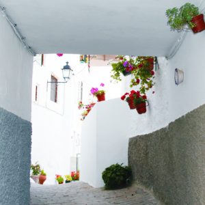
The Andalusian neighborhood is a magnificent urban example of the habitat and territorial organization during the Nasrid period. The Andalusian town was located on the top of a small hill, between the two rivers that run through the town.
The current urban layout of the Nasrid neighborhood, with its irregular, discontinuous morphology and adapted to the terraces of the land, is a direct heir to the Muslim nucleus. A large part of the urban fabric is maintained, in which dead-end alleys (adarves), community patios or corralones, tinaos or overpasses (sheds) stand out. A very traditional and little altered construction style and urban landscape are maintained. The building maintains certain formal characteristics that connect with the medieval origin of the population: houses with few openings, two floors with a utility room and storage on the upper floor. The remains of a medieval tower that formed part of the Algarinejo wall at the time of Muslim domination are preserved. In addition, throughout the neighborhood (Calle Cantera, Callejón de la Cueva, Calle Matutes, Corralón de las Angustias, Corralón de la Espigurra, Corralón de Matute) the houses have caves on the lower floor or in the cellar, which were the medieval origin from Algarinejo (Al-garín means The Caves in Arabic).

